
Business news for the stock market
SunMirror AG: Exploration Update – Moolyella and Kingston Keith Exploration Licences
Zug (pta034/04.10.2023/18:24 UTC+2)
As an update to previous communications, SunMirror AG (the "Company", "SunMirror", and together with its direct and indirect subsidiaries the "Group", Vienna Stock Exchange: ROR1; Frankfurt Stock Exchange: ROR; Düsseldorf Stock Exchange: ROR; ISIN CH0396131929), is pleased to provide further news on its exploration activities in Western Australia.
Highlights
Moolyella E 45/5573 – licence area 92 km2:-
- Just under 3,500 soil samples collected in the month of June-July by Terra Search Pty Ltd.
- All samples sent off for geochemical analysis at Nagrom Labs with lithium in soil grades returned ranging up to 460 ppm (parts per million) lithium (Li) with the mean at 107 ppm and the standard deviation at 60 ppm.
- 533 of the samples were over 167 ppm lithium (equivalent to the mean + 1 standard deviation), with 148 grading over 227 ppm lithium (the mean + 2 standard deviations). These high-grade areas where the soils are > 167 ppm are of immediate interest.
- Numerous areas, extending over more than 1km in length have now been identified within the licence area with high grade lithium values (> 167 ppm lithium) in soil, some of which correspond to the extensions of known mineralised (lithium-bearing) structures in adjacent exploration licences being explored by other lithium exploration companies. The total for the areas >167ppm lithium (assuming a 50m x 100m sample grid for the reported samples) is approximately 2.6 km2 compared to a total sampling area of 16 km2 (eg >16% of the sampled area).
- Follow up field visit scheduled for the second week of October to 'ground truth' these high-grade zones with the intention of identifying suitable sites for drilling.
- Proposed drill hole locations will subsequently be reviewed during a Heritage site visit prior to a submission to the authorities of a Plan of Work (POW) consisting of up to 5,000 metres of reverse circulation (RC) drilling scheduled for Q2 2024.
Kingston Keith E 53/1953 – licence area 152 km2:-
- Structural study completed by Southern Geoscience Consultants focused on identifying key structural, lithological and alteration features that could represent prospective lithium and gold targets within the licence area.
- Geological database over the entire licence area purchased from SensOre (a specialist minerals targeting company optimising discoveries through AI-enhance exploration) including a proprietary Artificial Intelligence (AI) Lithium Fertility Index study, which identified 3 'fertility' target areas within the middle part of the licence.
- Two pegmatite outcrops identified in the northern half of the licence block by an independent Geologist, which will be investigated further.
Laurent Quelin, CFO and interim CEO of SunMirror AG, comments: "I am delighted with the exploration progress that we have made on our 2 licences, Moolyella and Kingston Keith over the last 3 months. The soil sampling campaign recently undertaken at our Moolyella licence in June/July 2023 by Terra Search Pty Ltd took full advantage of the insight provided by SGC's lithostructural study, which itself was enhanced by reprocessing the original MagSpec aeromagnetic and radiometric data collected earlier in the year.
The laboratory tests performed on the collected soil samples have clearly identified distinct patterns in lithium grades within the licence, which appear to outline potential underground mineralised structures, some of which are very likely to be the continuations of structures discovered by our peers in neighbouring tenements. These results lay the foundations for a reverse-circulation drill program of up to 5,000 metres, which we anticipate starting sometime in Q2 2024.
As a next step we will consult with the local Nyamal Aboriginal Corporation to take on board any 'heritage' considerations prior to confirming exact drill locations for our Plan of Work (POW) submission to the authorities. This is in line with SunMirror's DNA of 'responsible exploration,' which involves engaging with the local communities where we work. Step-by-step we are advancing our key objective of defining an economical and sustainable lithium resource at Moolyella".
Exploration background to Moolyella Lithium Project
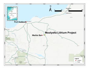
The Moolyella Project is located approximately 160 km southeast of Port Hedland (on the North West coast of Australia) and 15 km east of the settlement of Marble Bar, in the Pilbara Region of Western Australia. Access is via sealed road from Port Hedland
- Graphic, see PDF -
Location Map (above) of the Moolyella Licence in Western Australia
The area is known to be prospective for lithium as well as tin and tantalum. In the past it has been worked for its high-grade tin mineralization and more recently, explored by a variety of junior exploration companies focused on the numerous outcropping pegmatites that occur in the area, some of which contain lithium bearing minerals, such as spodumene. The licence area is large enough to contain a future mining operation if an economic ore body is identified.
Back in March 2012, a previous holder of the exploration licence, Lithex Resources Limited, published a JORC compliant inferred resource of tin and tantalum contained in eight of the historical tailings and waste stockpiles at Moolyella. Rare earths were also reported by Lithex at the property. The rare earth potential of the licence hasn't yet been evaluated by SunMirror as the current focus is on lithium mineralization.
- Graphic, see PDF -
Table 1 (above) – Moolyella tailings – Mineral Resource Estimate (February 2012) by MPR Geological Consultants Pty Ltd.
Preliminary metallurgical test work on the tailings conducted at that time by Nagrom Laboratory indicated recoveries of between 43.6% and 84.7% for tin (Sn), with an average recovery of 67.8% and between 17.1% and 66.3% for tantalum (Ta2O5), with an average recovery of 38.4%. The head grades of the bulk samples ranged from 90 to 1010 ppm Sn. The test work was conducted on 12 bulk samples (80 – 90 kg each) of the tailings material, from 7 of the 8 stockpiles included in the Mineral Resource Estimate.
In July 2021, focusing on the exploration for lithium deposits, SunMirror commissioned Geonomik Pty Ltd to carry out a 7-day site visit of the known pegmatite locations. Outcropping pegmatites were visited, although many of them extend deep under cover. Pegmatite outcroppings are typically the visible signs of lithium rock deposits. A few images from the field are shown below.
- Graphic, see PDF -
Figure above – shows multiple repetitions of outcropping pegmatite (see schematic model).
- Graphic, see PDF -
Schematic model showing the gently folded and relatively flat lying pegmatites horizons.
- Graphic, see PDF -
Photo (above) of an outcropping (weathered) pegmatite roughly 1 metre thick exposed in the granite.
In the first half of 2022, SunMirror completed preliminary (and mandatory) environmental studies at Moolyella. This was followed by an airborne aeromagnetic and radiometric survey in December 2022 with the specific remit of trying to identity the interpreted underground extension of the known mineralised pegmatites that outcrop within the licence area.
A lithostructural study of the aeromagnetic results was then completed by Southern Geoscience Consultants ("SGC", a specialist group of geoscientists focused on providing the highest quality integrated geophysical solutions to the resource industry) in May 2023, followed by the soil sampling campaign that is the subject of this current release.
Current Update – Moolyella exploration licence (E 45/5573) (92 km2) – Lithium
Based on the aeromagnetic results and interpretation by SGC, specific areas were then soil sampled in June-July 2023 on a 100m x 50m grid in the field and sent off for geochemical analysis in August-September. The combination of the various data sets (soil sample results, aeromagnetic and radiometric interpretation and known geological results from neighbouring tenements) has put SunMirror in a much better position to define the subsurface extensions of the known but limited outcropping lithium-bearing pegmatites. These targets will be the subject of a preliminary drill program, the first step towards defining a potential inferred resource on the property.
Of the 3252 soil samples collected and analysed, 533 samples reported values greater than 167 ppm lithium (the mean + 1 standard deviation) and out of these 148 samples reported values greater than 227 ppm (the mean + 2 standard deviations) as per below:-
- Graphic, see PDF -
The location of these sample areas reporting lithium values > 167 ppm will be where the Company plans to carry out its first drill program (currently scheduled to start sometime in Q2 2024).
The proposed drill hole locations will, however, be 'ground truthed' during a field visit in October 2023 to ensure they are not located in any 'heritage' or 'environmentally sensitive' areas before a Plan of Work (consisting of a drill program of up to 5,000 metres of reverse-circulation drilling) is submitted to the Western Australia Department of Mines.
Once the POW is approved, SunMirror should then be in a position to start drilling sometime in Q2 2024 (after the cyclone season). Assuming positive initial drill results, further drilling would follow in order to generate an initial maiden resource, and then convert the 'resource' from an 'inferred' category to an 'indicated' category. Once a JORC (Australasian Code for Reporting of Exploration Results, Mineral Resources and Ore Reserves 'the JORC Code' is a professional code of practice that sets minimum standards for Public Reporting of minerals Exploration Results, Mineral Resources and Ore Reserves) compliant resource has been modelled, a detailed Feasibility Study would follow to determine the economic viability to establishing a mining operation (or not).
Figures 1 and 2 below display the areas covered by the soil samples and describe the lithium grades reported in the soils.
Figure 1 (above) shows the location of all soil samples collected within the Moolyella Licence in June/July by Terra Search Pty Ltd. Their locations are marked by color coded squares according to their respective lithium values (in 'ppm' - parts per million). A number of very distinct high-grade zones (>140 ppm lithium) are clearly visible (pink squares). The 10 – 95 ppm lithium values in blue likely contain subtle mineralized structures which have been masked by areas of deep cover and will be investigated once the higher-grade lithium areas have been tested.
- Graphic, see PDF -
Figure 2 (above) is a 'heat map' image to show where lithium in soil grades exceed 167 ppm lithium (in red) representing grades greater than the mean + 1 standard deviation and > 227 ppm lithium (in cyan / blue) representing grades higher than the mean + 2 standard deviations). These zones represent high-grade lithium in soil target areas that will be assessed in the field this month for potential drill site locations.
Exploration background to the Kingston Keith Licence:
The Kingston Keith Licence is located in the Goldfields region of Western Australia, 450km north of Kalgoorlie. The nearest towns to the property are Wiluna, 60km to the northwest, and Leinster, 80 km to the south.
- Graphic, see PDF -
Location map (above) of the Kingston Keith Licence in Western Australia
The licence area was historically explored for nickel and more recently (prior to being acquired by SunMirror) for gold and is located in the Archaean Yilgarn Craton of Western Australia, a highly mineralised granite-greenstone terrane. The Company's tenement covers a 30km length of Agnew‐Wiluna Greenstone Belt, a particularly fertile sequence of rocks where mineralising processes, which occurred billions of years ago, have created many substantial deposits of gold and nickel sulphide. It is host to the Wiluna, Agnew, Matilda, Williamson, Kathleen Valley and Bellevue gold deposits. Rock types are mainly volcanics (felsics, mafics, ultramafics), gabbro, granite and sedimentary rocks. The Agnew‐Wiluna Greenstone Belt contains two major NNW trending regional structures; the Perseverance Fault and the northern extension of the Keith-Kilkenny Fault. It is a deep mantle-tapping crustal-scale structure, which is considered by geologists to be crucial to the formation of major nickel and gold deposits along its length.
In March 2022 Geonomik Pty Ltd was engaged by the Company to carry out a brief site visit to the property. Due to time constraints only a portion of the northern half of the licence area was accessed. Numerous historic gold diggings were found during the site visit confirming that the ground is prospective for gold mineralisation. The image below is taken from a drone overlooking the 'Enterprise North' prospect.
- Graphic, see PDF -
- Graphic, see PDF -
In January 2023, an airborne aeromagnetic and radiometric survey was performed by MagSpec, to identify potentially gold-bearing structures beneath the surface cover and also outline extent of the granite body in the southern part of the licence, which may have the potential to host lithium mineralisation.
Current Update - Kingston Keith Exploration Licence (E 53/1953) – Lithium + Gold +/- Nickel
In July 2023, Southern Geoscience Consultants (SGC) were engaged by the company to carry out enhanced magnetic, radiometric and digital terrain processing on the MagSpec airborne data (collected as noted above earlier in January 2023) for a structural interpretation focusing on the identification of key structural, lithological and alteration features that might be prospective lithium and gold targets within the licence.
This study has now been completed and the results reviewed along with licence-wide historical exploration data (compiled and audited by SensOre Ltd), which the company purchased earlier this month. Five (5) key areas deemed potentially prospective for lithium mineralisation have been identified. Two areas have zones of outcropping pegmatites (see image below) and the other three areas have been identified by SensOre's proprietary AI technology as having a significantly elevated Lithium Fertility Index.
Over the next two months the Company expects to commission a mandatory flora and fauna study over the most prospective target areas in order to be able to explore the area in more detail in an environmentally sensitive manner.
Before any detailed ground work begins, SunMirror must also complete a Land Access Agreement with the local traditional owners of the ground. Discussions are ongoing with the Tjiwarl Aboriginal Corporation (TAC) and a positive outcome is expected soon. Once the agreement is signed, the Company will carry out a detailed soil sampling program to identify mineralised targets for drilling. The same exploration process as reported above for Moolyella will follow, namely drilling to establish any potentially economic ore bodies for exploitation.
- Graphic, see PDF -
Photo (above) shows heavily weathered pegmatites that outcrop in the NE part of the Kingston Keith licence area
- Graphic, see PDF -
Figure 3 (above) shows the outline (in dark green) of the Company's Kingston Keith E 53/1953 exploration licence in Western Australia. The pink squares in the northern half of the licence block show the location of known outcropping pegmatites that will be investigated further to determine whether they contain lithium. The colored graded zones (blue – green – yellow orange – red) in the middle of the licence area represent the 'Lithium Fertility Index' as generated by SensOre's proprietary AI modelling work, where the red areas suggest a high possibility of there being lithium mineralization beneath the surface. These areas will be covered by soil sampling on a 100m x 50m grid to develop early drill targets.
These areas (see Figure 3 above) will be targeted by field mapping and soil / rock chip sampling program in the latter half of 2024 with the objective of generating early drill targets. It is likely that the historic 'Enterprise North' prospect (described earlier) will also be drilled as the workings are relatively shallow and the strike direction and underground extension potential remains untested.
The licence is also known to be highly prospective for intrusive related gold mineralisation, and the soil sampling program will cover the northern boundary of a dome-shaped granite that falls within the northern half of our licence area. Much of this area is covered by surface material, with little outcrop, but the Company hopes that the soil sampling program will identify possible targets for drilling.
- Graphic, see PDF -
Summary:
The Company's two exploration licences are located in well-established mining regions in the state of Western Australia and are deemed highly prospective for both precious and battery metals, the latter underpinning the global efforts of decarbonisation and the push towards electrification.
The recent soil sampling program at Moolyella and the aeromagnetic interpretation work at Kingston Keith are both natural progressions in SunMirror's continuing exploration efforts to identify prospective economic orebodies within the two licences. As a reminder, in 2022, SunMirror shifted its focus to advancing its own Moolyella and Kingston Keith projects after it abandoned the Latitude 66 acquisition. The Directors of the Company believe that the current results from both licences justify continuing to invest in the two projects.
The Company had previously reported that it had been proactively approached by various parties, which expressed an interest in reviewing the Kingston Keith licence. Those discussions have not resulted in any commercial agreement so far. At the time of this Press Release, a new party will be signing a Confidentiality Agreement to review our Kingston Keith database.
About SunMirror AG
The Group invests into strategic mineral exploration assets with a strong focus on sustainable green battery metals, such as cobalt, lithium and nickel, as well as copper and gold deposits in developed markets. The company aims to either produce minerals at a later stage or sell those assets to strategic buyers. SunMirror's key exploration assets acquired in 2020, are currently located in Western Australia but the Group aims to complement its portfolio with additional early stage mining licenses, focused on Europe with the ultimate aim of providing a secure, stable and sustainable supply of battery raw materials to support the electric revolution. SunMirror's core belief is that exploring for green battery metals must be accompanied by a sustainable approach to mining, thereby aiming to become a reference in terms of "responsible exploration".
The company's shares (ISIN CH0396131929) are listed on the Vienna Stock Exchange (official market, ticker: ROR1) and are traded on the regulated unofficial markets Frankfurt, Düsseldorf and Berlin (ticker: ROR) as well as on Xetra. For further information, please visit: www.sunmirror.com.
Contact
COMMUNICATION PUBLIC AFFAIRS
Alexander Schmitt-Geiger
Office Munich
Schwandorfer Str. 3
81549 Munich – Germany
Tel.:+49 (0) 89 51 39 96 00
Mail: schmitt@public-affairs-net.de
Web: www.public-affairs-net.de
(end)
| Emitter: |
SunMirror AG General-Guisan-Strasse 6 6300 Zug Switzerland |
|
|---|---|---|
| Contact Person: | Alexander Schmitt-Geiger, COMMUNICATION PUBLIC AFFAIRS | |
| Phone: | +49 89 51399600 | |
| E-Mail: | info@sunmirror.ch | |
| Website: | www.sunmirror.ch | |
| ISIN(s): | CH0396131929 (Share) | |
| Stock Exchange(s): | Vienna Stock Exchange (Official Trade) | |
| Other Stock Exchanges: | Freiverkehr in Berlin, Düsseldorf, Frankfurt, München, Stuttgart |